Volumetric Analysis
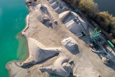
Stockpile Volume Measurement
Accurate inventory management starts with accurate volume data. Our drone-based volumetric surveys measure stockpiles of aggregate, sand, gravel, topsoil, mulch, and other bulk materials faster and more safely than traditional ground methods.
Advantages Over Traditional Methods
Conventional stockpile measurement requires personnel to walk on or around material piles — a safety risk and an access challenge on active sites. Drone surveys capture the entire pile surface from above in minutes, without anyone setting foot on the material. Instead of a handful of sample measurements, we capture millions of surface points with consistent density across the entire pile.
Industries Served
- Aggregate & Mining: Track extraction progress, verify haul quantities, and maintain accurate inventory records.
- Construction: Measure material deliveries, verify earthwork quantities, and calculate cut/fill volumes.
- Waste Management: Monitor landfill capacity, track filling rates, and document airspace consumption.
- Landscape Supply: Maintain accurate inventory of mulch, topsoil, and decorative stone products.
Accuracy & Reporting
Volumetric calculations typically achieve accuracy within 1–3% of actual volume when flown with properly established ground control and a documented base plane methodology. Each report includes calculated volume, measurement methodology, base plane definition, and supporting imagery. Results are reported in cubic yards or cubic meters. Periodic flights provide change tracking over time.